
Make a donation
Gear up for your next adventure:
As an Amazon Associate, this site earns from qualifying purchases at no extra cost to you.
Vadodara topographic map
Click on the map to display elevation.
Make a donation
Gear up for your next adventure:
As an Amazon Associate, this site earns from qualifying purchases at no extra cost to you.
Vadodara
Vadodara is located at 22°18′N 73°11′E / 22.30°N 73.19°E / 22.30; 73.19 in western India at an elevation of 128 ft (39 m). It is the 10th-largest city in India with an area of 400 km2 (150 sq mi) and a population of 3.5 million, according to the 2010–11 census. The city sits on the banks of the Vishwamitri River, in central Gujarat. The Vishwamitri frequently dries up in the summer, leaving only a small stream of water. The city is located on the fertile plain between the Mahi and Narmada Rivers. According to the Bureau of Indian Standards, the cosmopolis falls under seismic zone-III, on a scale of I to V (in order of increasing proneness to earthquakes).
Make a donation
Gear up for your next adventure:
As an Amazon Associate, this site earns from qualifying purchases at no extra cost to you.
About this map
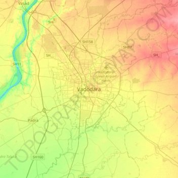
Name: Vadodara topographic map, elevation, terrain.
Average elevation: 36 m
Minimum elevation: 0 m
Maximum elevation: 71 m
Make a donation
Gear up for your next adventure:
As an Amazon Associate, this site earns from qualifying purchases at no extra cost to you.
Other topographic maps
Click on a map to view its topography, its elevation and its terrain.