
Cotswold topographic map
Interactive map
Click on the map to display elevation.
About this map
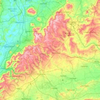
Name: Cotswold topographic map, elevation, terrain.
Average elevation: 118 m
Minimum elevation: 6 m
Maximum elevation: 328 m
Other topographic maps
Click on a map to view its topography, its elevation and its terrain.
Silk Wood
United Kingdom > England > Cotswold > Westonbirt
Silk Wood, Westonbirt with Lasborough, Westonbirt, Cotswold, Gloucestershire, South West England, England, United Kingdom
Average elevation: 141 m
Moreton-in-Marsh
United Kingdom > England > Cotswold > Moreton-in-Marsh
Moreton-in-Marsh, Cotswold, Gloucestershire, South West England, England, GL56 0AJ, United Kingdom
Average elevation: 145 m