
Make a donation
Gear up for your next adventure:
As an Amazon Associate, this site earns from qualifying purchases at no extra cost to you.
Rovaniemi topographic map
Click on the map to display elevation.
Make a donation
Gear up for your next adventure:
As an Amazon Associate, this site earns from qualifying purchases at no extra cost to you.
About this map
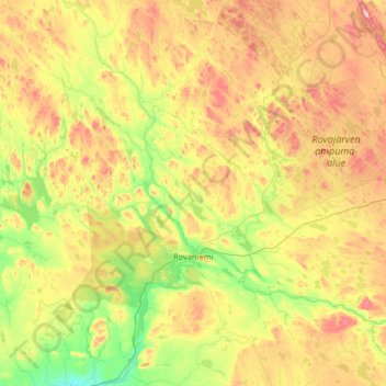
Name: Rovaniemi topographic map, elevation, terrain.
Average elevation: 167 m
Minimum elevation: 36 m
Maximum elevation: 491 m
Make a donation
Gear up for your next adventure:
As an Amazon Associate, this site earns from qualifying purchases at no extra cost to you.
Other topographic maps
Click on a map to view its topography, its elevation and its terrain.
Kilpisjärvi
Although Kilpisjärvi is one of the largest villages in Enontekiö, it is still quite small. In 2000 its population was recorded as 114. Like most Sami villages, Kilpisjärvi is built mainly around one major road, Käsivarrentie, or the "Arm Road" and Neljäntuulentie, or the "Four Winds' Road" — also known…
Average elevation: 576 m
Make a donation
Gear up for your next adventure:
As an Amazon Associate, this site earns from qualifying purchases at no extra cost to you.
Make a donation
Gear up for your next adventure:
As an Amazon Associate, this site earns from qualifying purchases at no extra cost to you.