Geolocate

Cartwright topographic map

Click on the map to display elevation.

About this map

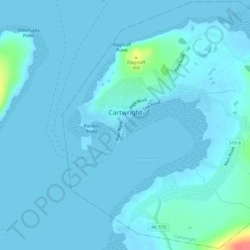
Name: Cartwright topographic map, elevation, terrain.

Location: Cartwright, Labrador, Newfoundland and Labrador, Canada (53.69084 -57.03189 53.71881 -56.98415)

Average elevation: 4 m

Minimum elevation: -2 m

Maximum elevation: 58 m

Other topographic maps

Click on a map to view its topography, its elevation and its terrain.

Gear up for your next adventure:

👣Snake & Scrub Gaiters - Protection against spinifex, mud, and snakes while walking off-track
🥾Heavy Duty Hiking Boots - Ankle-supporting boots for carrying heavy packs on steep contours
👟Lightweight Trail Runners - Agile footwear for fast movement over rugged Australian terrain
📦Crushproof Equipment Cases - Safe transport for sensitive surveying and mapping instruments
👖Convertible Hiking Trousers - Zip-off legs to adapt to changing temperatures throughout the day

As an Amazon Associate, this site earns from qualifying purchases at no extra cost to you.