
Make a donation
Gear up for your next adventure:
As an Amazon Associate, this site earns from qualifying purchases at no extra cost to you.
Area B (Discovery Islands/Mainland Inlets) topographic map
Click on the map to display elevation.
Make a donation
Gear up for your next adventure:
As an Amazon Associate, this site earns from qualifying purchases at no extra cost to you.
About this map
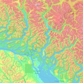
Name: Area B (Discovery Islands/Mainland Inlets) topographic map, elevation, terrain.
Average elevation: 969 m
Minimum elevation: -1 m
Maximum elevation: 3,795 m
Make a donation
Gear up for your next adventure:
As an Amazon Associate, this site earns from qualifying purchases at no extra cost to you.
Other topographic maps
Click on a map to view its topography, its elevation and its terrain.
Mansons Landing
Canada > British Columbia > Strathcona Regional District > Area C (Cortes Island) > Mansons Landing
Average elevation: 32 m
Campbell River
Canada > British Columbia > Strathcona Regional District > Campbell River
Average elevation: 108 m
Tahsis
Canada > British Columbia > Strathcona Regional District > Tahsis > Tahsis
Average elevation: 252 m
Read Island
Canada > British Columbia > Strathcona Regional District > Area B (Discovery Islands/Mainland Inlets) > Read Island
Average elevation: 38 m
Make a donation
Gear up for your next adventure:
As an Amazon Associate, this site earns from qualifying purchases at no extra cost to you.
Mount Clarence
Canada > British Columbia > Strathcona Regional District > Area B (Discovery Islands/Mainland Inlets)
Average elevation: 711 m