
Andros topographic map
Interactive map
Click on the map to display elevation.
About this map
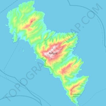
Name: Andros topographic map, elevation, terrain.
Average elevation: 83 m
Minimum elevation: 0 m
Maximum elevation: 994 m
Other topographic maps
Click on a map to view its topography, its elevation and its terrain.
Lipsi
Greece > Aegean > Kalmynos Regional Unit > Lipsi
Lipsi, Lipsi Municipality, Kalmynos Regional Unit, South Aegean, Aegean, 850 01, Greece
Average elevation: 19 m
Paros
Greece > Aegean > Paros Regional Unit
Paros, Paros Regional Unit, South Aegean, Aegean, Greece
Average elevation: 69 m
Amali
Greece > Aegean > Rhodes Regional Unit > Livadia
Amali, Livadia, Municipality of Tilos, Rhodes Regional Unit, South Aegean, Aegean, 85002, Greece
Average elevation: 149 m
Tinos
Greece > Aegean > Tinos Regional Unit
Tinos, Tinos Regional Unit, South Aegean, Aegean, Greece
Average elevation: 64 m
Chios
Greece > Aegean > Chios Regional Unit
Chios, Chios Regional Unit, Northern Aegean, Aegean, Greece
Average elevation: 99 m
Kako Prinari
Greece > Aegean > Kako Prinari
Kako Prinari, Kos, Kos Regional Unit, South Aegean Region, Aegean, 85300, Greece
Average elevation: 36 m
Santorini
Greece > Aegean > Thira Regional Unit > Thira Municipal Unit
Santorini, Thira Municipal Unit, Municipality of Thira, Thira Regional Unit, South Aegean, Aegean, Greece
Average elevation: 30 m
Notio Aspronisi West
Notio Aspronisi West, Δήμος Λειψών, Kalmynos Regional Unit, South Aegean Region, Aegean, Greece
Average elevation: 2 m
Mykonos
Greece > Aegean > Mykonos Regional Unit > Agios Stefanos
Mykonos, Agios Stefanos, Municipality of Mykonos, Mykonos Regional Unit, South Aegean, Aegean, 846 00, Greece
Average elevation: 38 m