
Make a donation
Gear up for your next adventure:
As an Amazon Associate, this site earns from qualifying purchases at no extra cost to you.
Mazandaran Province topographic map
Click on the map to display elevation.
Make a donation
Gear up for your next adventure:
As an Amazon Associate, this site earns from qualifying purchases at no extra cost to you.
Mazandaran Province
Mazandaran province naturally comes under the influence of the geographical latitude, the Alborz mountain range, elevation from sea level, distance from the sea, and the southern barren areas of Turkmenistan, local and regional air currents, and versatile vegetation cover. These conditions result in the climatic division of the province into three types: (1) Moderate Caspian weather with hot, humid summers and mild, humid winters, (2) moderate mountainous weather with long, cold and freezing winters and mild and short summers, and (3) cold mountainous weather with long freezing winters and short cool summers. There is often snowfall during most of the seasons in the latter region, which continues till mid-summer.
Make a donation
Gear up for your next adventure:
As an Amazon Associate, this site earns from qualifying purchases at no extra cost to you.
About this map
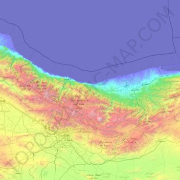
Name: Mazandaran Province topographic map, elevation, terrain.
Location: Mazandaran Province, Iran (35.76136 50.33429 37.13744 54.17297)
Average elevation: 863 m
Minimum elevation: -29 m
Maximum elevation: 5,470 m
Make a donation
Gear up for your next adventure:
As an Amazon Associate, this site earns from qualifying purchases at no extra cost to you.
Other topographic maps
Click on a map to view its topography, its elevation and its terrain.
Shurab
Iran > South Khorasan Province > Birjand County > دهستان شاخن > Foorjan
Average elevation: 1,935 m
Espakeh
Iran > Sistan and Baluchestan Province > Lashar County > دهستان لاشارشمالی
Average elevation: 776 m
Now
Iran > Chaharmahal and Bakhtiyari Province > Lordegan County > Sardasht Rural District
Average elevation: 1,871 m
Make a donation
Gear up for your next adventure:
As an Amazon Associate, this site earns from qualifying purchases at no extra cost to you.
Gold
Iran > Chaharmahal and Bakhtiyari Province > Lordegan County > Sardasht Rural District
Average elevation: 1,739 m
Make a donation
Gear up for your next adventure:
As an Amazon Associate, this site earns from qualifying purchases at no extra cost to you.
Shalan
Iran > Kermanshah Province > Kermanshah County > (هوره سو)دهستان قره سو
Average elevation: 1,515 m
Make a donation
Gear up for your next adventure:
As an Amazon Associate, this site earns from qualifying purchases at no extra cost to you.
Make a donation
Gear up for your next adventure:
As an Amazon Associate, this site earns from qualifying purchases at no extra cost to you.
Make a donation
Gear up for your next adventure:
As an Amazon Associate, this site earns from qualifying purchases at no extra cost to you.
Kerrawa
Iran > Kurdistan Province > Sarvabad County > دهستان رزآب > Kerrawa
Average elevation: 1,426 m
Sib
Iran > Sistan and Baluchestan Province > Sib and Suran County > دهستان سیب وسوران > Sib
Average elevation: 1,146 m