Geolocate

Middlesbrough topographic map

Click on the map to display elevation.

About this map
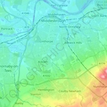
Name: Middlesbrough topographic map, elevation, terrain.

Location: Middlesbrough, Tees Valley, England, United Kingdom (54.51076 -1.28250 54.59140 -1.16067)

Average elevation: 26 m

Minimum elevation: -13 m

Maximum elevation: 131 m

Gear up for your next adventure:

🧴Sunscreen SPF - Sun protection for outdoor activities
🍳Camping Cookware - Cookware sets for outdoor meals
🥾Hiking Boots - Durable hiking boots for trails and rough terrain
🛠️Outdoor Repair Kits - Gear repair kits
🎒Daypacks - Compact backpacks for short hikes

As an Amazon Associate, this site earns from qualifying purchases at no extra cost to you.