Geolocate

New Hartley topographic map

Click on the map to display elevation.

About this map

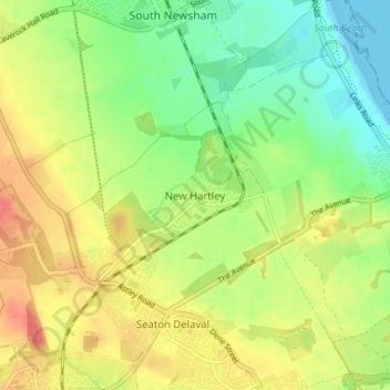
Name: New Hartley topographic map, elevation, terrain.

Location: New Hartley, Northumberland, North of Tyne, England, NE25 0SU, United Kingdom (55.06490 -1.54040 55.10490 -1.50040)

Average elevation: 27 m

Minimum elevation: 0 m

Maximum elevation: 56 m

Other topographic maps

Click on a map to view its topography, its elevation and its terrain.

Chollerton

United Kingdom > England > Northumberland

Average elevation: 170 m

Rothbury

United Kingdom > England > Northumberland

Average elevation: 176 m

Ponteland

United Kingdom > England > Northumberland

Average elevation: 76 m

Horsley

United Kingdom > England > Northumberland

Average elevation: 93 m

Gear up for your next adventure:

💧Personal Water Filters - Drink safely from streams and lakes identified on your map
💡Collapsible Camping Lanterns - Illuminate your base camp or tent for map studying at night
🛰️Handheld GPS Units - Rugged GPS devices for tracking coordinates and elevation in the Australian bush
GPS Watches - GPS watches for outdoor sports
🧤Hiking Gloves - Protective gloves for outdoor use

As an Amazon Associate, this site earns from qualifying purchases at no extra cost to you.