
Abha topographic map
Interactive map
Click on the map to display elevation.
About this map
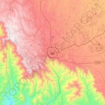
Name: Abha topographic map, elevation, terrain.
Location: Abha, 'Asir Province, 26442, Saudi Arabia (18.05643 42.34436 18.37643 42.66436)
Average elevation: 1,994 m
Minimum elevation: 722 m
Maximum elevation: 2,991 m
Abha is located in the southern region of Asir at an elevation of about 2,270 metres (7,450 feet) above sea level.[citation needed] Abha lies on the western edge of Mount Al-Hijaz,[2] near Jabal Sawda, the highest peak in Saudi Arabia. Treating the Asir Mountains as part of the Sarawat, the landscape is otherwise dominated by the Sarawat Mountains.[7]