Geolocate

Oʻahu topographic map

Click on the map to display elevation.

About this map

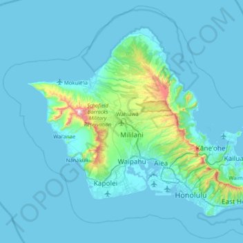
Name: Oʻahu topographic map, elevation, terrain.

Location: Oʻahu, Honolulu County, Hawaii, United States (21.25482 -158.28058 21.71201 -157.64863)

Average elevation: 79 m

Minimum elevation: -3 m

Maximum elevation: 1,225 m

Other topographic maps

Click on a map to view its topography, its elevation and its terrain.

Keapuka

United States > Hawaii > Honolulu County > Kaneohe

Average elevation: 118 m

Diamond Head

United States > Hawaii > Honolulu County > Honolulu

Average elevation: 26 m

Gear up for your next adventure:

📱Shockproof Phone Cases - Extra protection for your smartphone against drops on rocky terrain
🧤Thermal Hiking Gloves - Keep your hands warm and functional during high-altitude winter treks
Altimeter Watches - Watches with altitude tracking
📸Action Cameras - Record your journey across interesting topographic features in 4K
🔋Solar Power Banks - Charge your phone and GPS using the sun while deep in the bush

As an Amazon Associate, this site earns from qualifying purchases at no extra cost to you.