Kętrzyn County topographic map
Click on the map to display elevation.
About this map

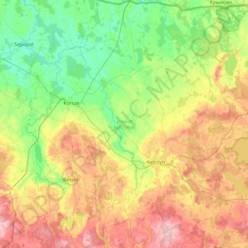
Name: Kętrzyn County topographic map, elevation, terrain.
Location: Kętrzyn County, Warmian-Masurian Voivodeship, Poland (53.93819 21.02201 54.33482 21.60231)
Average elevation: 93 m
Minimum elevation: 25 m
Maximum elevation: 214 m
Other topographic maps
Click on a map to view its topography, its elevation and its terrain.

Bartoszyce County
Poland > Warmian-Masurian Voivodeship
Bartoszyce County, Warmian-Masurian Voivodeship, Poland
Average elevation: 98 m

Elbląg County
Poland > Warmian-Masurian Voivodeship
Elbląg County, Warmian-Masurian Voivodeship, Poland
Average elevation: 55 m

Parys
Poland > Warmian-Masurian Voivodeship > Kętrzyn County
Parys, gmina Korsze, Kętrzyn County, Warmian-Masurian Voivodeship, Poland
Average elevation: 52 m

Kętrzyn
Poland > Warmian-Masurian Voivodeship > Kętrzyn County
Kętrzyn, Kętrzyn County, Warmian-Masurian Voivodeship, Poland
Average elevation: 101 m

Mrągowo County
Poland > Warmian-Masurian Voivodeship
Mrągowo County, Warmian-Masurian Voivodeship, Poland
Average elevation: 141 m

Mrągowo
Poland > Warmian-Masurian Voivodeship
Mrągowo, powiat mrągowski, Warmian-Masurian Voivodeship, 11-700, Poland
Average elevation: 150 m

Olsztynek
Poland > Warmian-Masurian Voivodeship
Olsztynek, gmina Olsztynek, powiat olsztyński, Warmian-Masurian Voivodeship, 11-015, Poland
Average elevation: 174 m

Reszel
Poland > Warmian-Masurian Voivodeship
Reszel, gmina Reszel, powiat kętrzyński, Warmian-Masurian Voivodeship, Poland
Average elevation: 109 m

Bartoszyce
Poland > Warmian-Masurian Voivodeship
Bartoszyce, powiat bartoszycki, Warmian-Masurian Voivodeship, 11-200, Poland
Average elevation: 56 m