
Thank you for supporting this site ❤️
Make a donation
Make a donation
Gear up for your next adventure:
As an Amazon Associate, this site earns from qualifying purchases at no extra cost to you.
Kajaani topographic map
Click on the map to display elevation.
Thank you for supporting this site ❤️
Make a donation
Make a donation
Gear up for your next adventure:
As an Amazon Associate, this site earns from qualifying purchases at no extra cost to you.
About this map
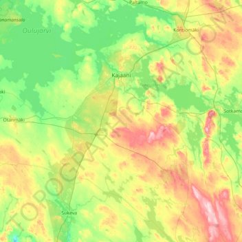
Name: Kajaani topographic map, elevation, terrain.
Location: Kajaani, Kajaani sub-region, Kainuu, Mainland Finland, Finland (63.84471 26.74838 64.36518 28.15803)
Average elevation: 169 m
Minimum elevation: 97 m
Maximum elevation: 365 m
Thank you for supporting this site ❤️
Make a donation
Make a donation
Gear up for your next adventure:
As an Amazon Associate, this site earns from qualifying purchases at no extra cost to you.