
Make a donation
Gear up for your next adventure:
As an Amazon Associate, this site earns from qualifying purchases at no extra cost to you.
Goroka topographic map
Click on the map to display elevation.
Make a donation
Gear up for your next adventure:
As an Amazon Associate, this site earns from qualifying purchases at no extra cost to you.
Goroka
Goroka has a subtropical highland climate (Cfb). Due to altitude Goroka features warm to very warm afternoons and cool to mild mornings year-round, with heavy rainfall most of the year and low rainfall from June to September.
Make a donation
Gear up for your next adventure:
As an Amazon Associate, this site earns from qualifying purchases at no extra cost to you.
About this map
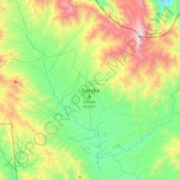
Name: Goroka topographic map, elevation, terrain.
Average elevation: 1,890 m
Minimum elevation: 1,088 m
Maximum elevation: 3,513 m
Make a donation
Gear up for your next adventure:
As an Amazon Associate, this site earns from qualifying purchases at no extra cost to you.