
Mickleham topographic map
Interactive map
Click on the map to display elevation.
About this map
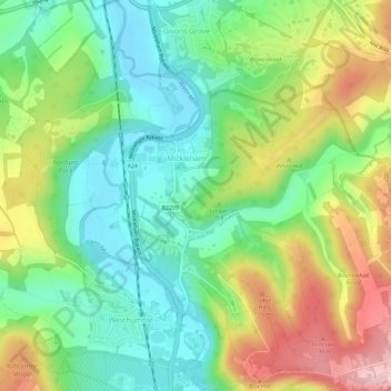
Name: Mickleham topographic map, elevation, terrain.
Location: Mickleham, Mole Valley, Surrey, England, United Kingdom (51.24975 -0.34926 51.28003 -0.29126)
Average elevation: 103 m
Minimum elevation: 32 m
Maximum elevation: 217 m
Other topographic maps
Click on a map to view its topography, its elevation and its terrain.
Ashtead
United Kingdom > England > Surrey > Mole Valley
Ashtead, Mole Valley, Surrey, England, KT21 2FH, United Kingdom
Average elevation: 75 m