Geolocate

Wrexham topographic map

Click on the map to display elevation.

About this map

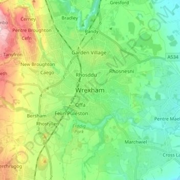
Name: Wrexham topographic map, elevation, terrain.

Location: Wrexham, Wales, LL11 1AP, United Kingdom (52.88651 -3.15379 53.20651 -2.83379)

Average elevation: 139 m

Minimum elevation: 2 m

Maximum elevation: 561 m

Other topographic maps

Click on a map to view its topography, its elevation and its terrain.

Gwersyllt

United Kingdom > Wales > Wrexham

Average elevation: 112 m

Penycae

United Kingdom > Wales > Wrexham

Average elevation: 350 m

Rhosddu

United Kingdom > Wales > Wrexham

Average elevation: 88 m

Bangor-on-Dee

United Kingdom > Wales > Wrexham

Average elevation: 30 m

Cefn

United Kingdom > Wales > Wrexham > Acrefair

Average elevation: 142 m

Gear up for your next adventure:

🧭Global Orienteering Compass - High-precision liquid-filled compasses for accurate map reading and navigation
📡Portable Emergency Radios - Stay informed about weather warnings and bushfire alerts
Altimeter Barometer Watches - Outdoor watches with built-in sensors to track altitude changes and weather shifts
🛌Sleeping Mats - Insulated mats for camping comfort
🖼️Scratch-off Australia Map - Track the regions and peaks you have explored geographically

As an Amazon Associate, this site earns from qualifying purchases at no extra cost to you.