
Make a donation
Gear up for your next adventure:
As an Amazon Associate, this site earns from qualifying purchases at no extra cost to you.
Dali City topographic map
Click on the map to display elevation.
Make a donation
Gear up for your next adventure:
As an Amazon Associate, this site earns from qualifying purchases at no extra cost to you.
Dali City
Its low latitude tempered by its high elevation, Dali has a mild subtropical highland climate (Köppen Cwb) with short, mild, dry winters and warm, rainy summers. Frost may occur in winter but the days still generally warm up to 16 °C (61 °F) or more. During summer, a majority of the days features some rainfall and daytime temperatures rise to 25 °C (77 °F). A great majority of the year's rainfall occurs from June to October. December 2013 was particularly marked for its high snowfall.
Make a donation
Gear up for your next adventure:
As an Amazon Associate, this site earns from qualifying purchases at no extra cost to you.
About this map
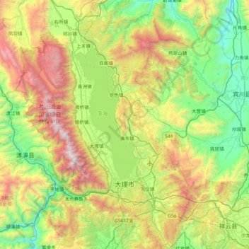
Name: Dali City topographic map, elevation, terrain.
Location: Dali City, Dali Bai Autonomous Prefecture, Yunnan, China (25.42414 99.97839 26.07829 100.43644)
Average elevation: 2,172 m
Minimum elevation: 1,283 m
Maximum elevation: 4,062 m
Make a donation
Gear up for your next adventure:
As an Amazon Associate, this site earns from qualifying purchases at no extra cost to you.
Other topographic maps
Click on a map to view its topography, its elevation and its terrain.
Yingjiang County
China > Yunnan > Yingjiang County
Yingjiang county is mountainous with several alluvial plains. The county has various climate types, with ranges from the tropical, the subtropical, to the temperate zones. Intact forests can be seen in the mountains above 2,000 m (6,600 ft). The elevations vary from 210 to 3,404.6 m (689 to 11,170 ft).
Average elevation: 1,428 m
Make a donation
Gear up for your next adventure:
As an Amazon Associate, this site earns from qualifying purchases at no extra cost to you.