
Make a donation
Gear up for your next adventure:
As an Amazon Associate, this site earns from qualifying purchases at no extra cost to you.
Vari Municipal Unit topographic map
Click on the map to display elevation.
Make a donation
Gear up for your next adventure:
As an Amazon Associate, this site earns from qualifying purchases at no extra cost to you.
About this map
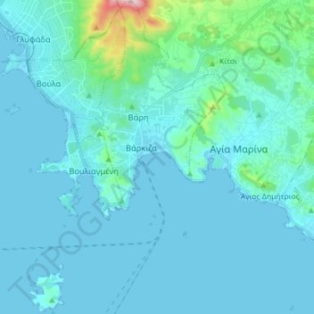
Name: Vari Municipal Unit topographic map, elevation, terrain.
Average elevation: 53 m
Minimum elevation: -6 m
Maximum elevation: 616 m
Make a donation
Gear up for your next adventure:
As an Amazon Associate, this site earns from qualifying purchases at no extra cost to you.
Other topographic maps
Click on a map to view its topography, its elevation and its terrain.
Nea Makri
Greece > Attica > Regional Unit of East Attica > Nea Makri Municipal Unit
Average elevation: 122 m
Λαγονήσι
Greece > Attica > Regional Unit of East Attica > Kalyvia Thorikou Municipal Unit
Average elevation: 30 m
Saronis
Greece > Attica > Regional Unit of East Attica > Saronida Municipal Unit
Average elevation: 48 m
Make a donation
Gear up for your next adventure:
As an Amazon Associate, this site earns from qualifying purchases at no extra cost to you.
Cape Sounio
Greece > Attica > Regional Unit of East Attica > Lavreotiki Municipal Unit > Kato Sounio
Average elevation: 9 m
Cape Sounion
Greece > Attica > Regional Unit of East Attica > Lavreotiki Municipal Unit
Average elevation: 8 m
Make a donation
Gear up for your next adventure:
As an Amazon Associate, this site earns from qualifying purchases at no extra cost to you.
Artemida
Greece > Attica > Regional Unit of East Attica > Artemida Municipal Unit
Average elevation: 38 m
Spata
Greece > Attica > Regional Unit of East Attica > Spata-Loutsa Municipal Unit
Average elevation: 115 m
Make a donation
Gear up for your next adventure:
As an Amazon Associate, this site earns from qualifying purchases at no extra cost to you.
Saronis
Greece > Attica > Regional Unit of East Attica > Saronida Municipal Unit
Average elevation: 48 m