
Make a donation
Gear up for your next adventure:
As an Amazon Associate, this site earns from qualifying purchases at no extra cost to you.
Kullaberg topographic map
Click on the map to display elevation.
Make a donation
Gear up for your next adventure:
As an Amazon Associate, this site earns from qualifying purchases at no extra cost to you.
Kullaberg
Kullaberg (Swedish pronunciation: [kɵlaˈbærj]) is a peninsula and nature reserve of land protruding into the Kattegat in Höganäs Municipality near the town of Mölle in southwest Sweden. The site in the province of Skåne is an area of considerable biodiversity supporting a number of rare species and has been designated as an Important Bird Area (IBA) in Sweden as well as a Special Protection Area (SPA). The terrain is dominated by steep cliffs rising from the sea and rocky outcrops on the ridge above, the highest elevation being Håkull at 188 metres. Ridgetop vegetation includes a mixed hardwood broadleaf forest consisting of birch, beech, oak and pine trees with an understory of hawthorn, juniper, wild honeysuckle and blackthorn. Among the notable rare plants are spring vetchling, Lathyrus sphaericus.
Make a donation
Gear up for your next adventure:
As an Amazon Associate, this site earns from qualifying purchases at no extra cost to you.
About this map
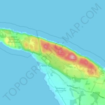
Name: Kullaberg topographic map, elevation, terrain.
Location: Kullaberg, Mölle, Höganäs kommun, Skåne County, 263 77, Sweden (56.27783 12.45335 56.30169 12.55388)
Average elevation: 22 m
Minimum elevation: 0 m
Maximum elevation: 174 m
Make a donation
Gear up for your next adventure:
As an Amazon Associate, this site earns from qualifying purchases at no extra cost to you.