
Make a donation
Gear up for your next adventure:
As an Amazon Associate, this site earns from qualifying purchases at no extra cost to you.
Gaoping City topographic map
Click on the map to display elevation.
Make a donation
Gear up for your next adventure:
As an Amazon Associate, this site earns from qualifying purchases at no extra cost to you.
About this map
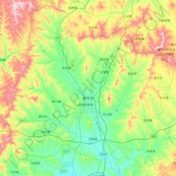
Name: Gaoping City topographic map, elevation, terrain.
Location: Gaoping City, Jincheng, Shanxi, China (35.65002 112.71202 35.98728 113.15630)
Average elevation: 985 m
Minimum elevation: 768 m
Maximum elevation: 1,399 m
Make a donation
Gear up for your next adventure:
As an Amazon Associate, this site earns from qualifying purchases at no extra cost to you.
Other topographic maps
Click on a map to view its topography, its elevation and its terrain.
Linfen
China > Shanxi > Linfen > Jiefanglu Subdistrict
Within its borders Linfen City has a variety of topographical features. It is characterised as having a "U" shape, with its mountains, covering 29.2% of the prefectural area, on all four cardinal directions, a basin, the Linfen Basin (临汾盆地), covering 19.4%, in the middle, and intervening hills,…
Average elevation: 582 m