
Thank you for supporting this site ❤️
Make a donation
Make a donation
Gear up for your next adventure:
As an Amazon Associate, this site earns from qualifying purchases at no extra cost to you.
Ellensberg topographic map
Click on the map to display elevation.
Thank you for supporting this site ❤️
Make a donation
Make a donation
Gear up for your next adventure:
As an Amazon Associate, this site earns from qualifying purchases at no extra cost to you.
About this map
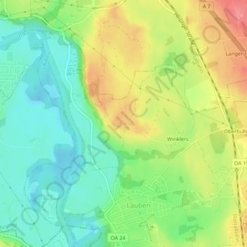
Name: Ellensberg topographic map, elevation, terrain.
Location: Ellensberg, Lauben, Landkreis Oberallgäu, Bavaria, Germany (47.78821 10.29689 47.78997 10.30113)
Average elevation: 673 m
Minimum elevation: 639 m
Maximum elevation: 720 m
Thank you for supporting this site ❤️
Make a donation
Make a donation
Gear up for your next adventure:
As an Amazon Associate, this site earns from qualifying purchases at no extra cost to you.