
Make a donation
Gear up for your next adventure:
As an Amazon Associate, this site earns from qualifying purchases at no extra cost to you.
Combloux topographic map
Click on the map to display elevation.
Make a donation
Gear up for your next adventure:
As an Amazon Associate, this site earns from qualifying purchases at no extra cost to you.
About this map
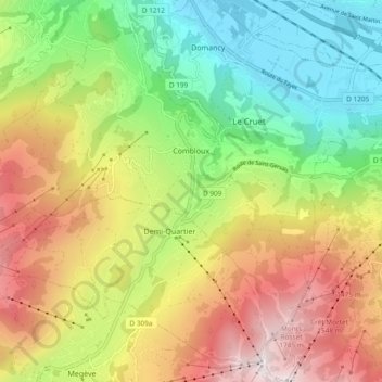
Name: Combloux topographic map, elevation, terrain.
Average elevation: 1,104 m
Minimum elevation: 547 m
Maximum elevation: 1,825 m
Make a donation
Gear up for your next adventure:
As an Amazon Associate, this site earns from qualifying purchases at no extra cost to you.
Other topographic maps
Click on a map to view its topography, its elevation and its terrain.
les Plans
France > Auvergne-Rhône-Alpes > Upper Savoy > Chamonix-Mont-Blanc
Average elevation: 1,416 m
Le Blanc Chat
France > Auvergne-Rhône-Alpes > Upper Savoy > Épagny Metz-Tessy
Average elevation: 487 m
Make a donation
Gear up for your next adventure:
As an Amazon Associate, this site earns from qualifying purchases at no extra cost to you.
Les Bossons
France > Auvergne-Rhône-Alpes > Upper Savoy > Chamonix-Mont-Blanc
Average elevation: 1,376 m
Aiguille Verte
France > Auvergne-Rhône-Alpes > Upper Savoy > Chamonix-Mont-Blanc
Average elevation: 3,224 m
Aiguille du Midi
France > Auvergne-Rhône-Alpes > Upper Savoy > Chamonix-Mont-Blanc
Average elevation: 3,097 m
Make a donation
Gear up for your next adventure:
As an Amazon Associate, this site earns from qualifying purchases at no extra cost to you.
Make a donation
Gear up for your next adventure:
As an Amazon Associate, this site earns from qualifying purchases at no extra cost to you.
Argentière
France > Auvergne-Rhône-Alpes > Upper Savoy > Chamonix-Mont-Blanc > Argentière
Average elevation: 1,674 m
Refuge de L'Envers des Aiguilles
France > Auvergne-Rhône-Alpes > Upper Savoy > Chamonix-Mont-Blanc
Average elevation: 2,547 m
Saint-Jeoire
France > Auvergne-Rhône-Alpes > Upper Savoy > Saint-Jeoire > Saint-Jeoire
Average elevation: 830 m
Chamonix-Mont-Blanc
France > Auvergne-Rhône-Alpes > Upper Savoy > Chamonix-Mont-Blanc > Chamonix-Mont-Blanc
Average elevation: 1,787 m
Make a donation
Gear up for your next adventure:
As an Amazon Associate, this site earns from qualifying purchases at no extra cost to you.
Mont Gerbet
France > Auvergne-Rhône-Alpes > Upper Savoy > Duingt > Mont Gerbet
Average elevation: 534 m
Make a donation
Gear up for your next adventure:
As an Amazon Associate, this site earns from qualifying purchases at no extra cost to you.
Le Chesnet
France > Auvergne-Rhône-Alpes > Upper Savoy > La Roche-sur-Foron
Average elevation: 1,184 m
Tré-le-Champ - le Haut
France > Auvergne-Rhône-Alpes > Upper Savoy > Chamonix-Mont-Blanc
Average elevation: 1,737 m
Make a donation
Gear up for your next adventure:
As an Amazon Associate, this site earns from qualifying purchases at no extra cost to you.
La Vendanche
France > Auvergne-Rhône-Alpes > Upper Savoy > Le Grand-Bornand
Average elevation: 1,401 m
Make a donation
Gear up for your next adventure:
As an Amazon Associate, this site earns from qualifying purchases at no extra cost to you.
Make a donation
Gear up for your next adventure:
As an Amazon Associate, this site earns from qualifying purchases at no extra cost to you.
Plan Montmin
France > Auvergne-Rhône-Alpes > Upper Savoy > Talloires-Montmin
Average elevation: 1,080 m