
Make a donation
Gear up for your next adventure:
As an Amazon Associate, this site earns from qualifying purchases at no extra cost to you.
Red Lodge topographic map
Click on the map to display elevation.
Make a donation
Gear up for your next adventure:
As an Amazon Associate, this site earns from qualifying purchases at no extra cost to you.
Red Lodge
Red Lodge experiences a continental climate (Köppen Dfb) with cold, somewhat dry winters and warm, wetter summers. Summers are cooler than in areas of Montana further north, due to the high elevation. Winters however, are milder than areas further to the east due to the chinook wind influence, as with most of Montana.
Make a donation
Gear up for your next adventure:
As an Amazon Associate, this site earns from qualifying purchases at no extra cost to you.
About this map
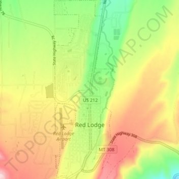
Name: Red Lodge topographic map, elevation, terrain.
Location: Red Lodge, Carbon County, Montana, United States (45.17150 -109.26051 45.21889 -109.23767)
Average elevation: 1,720 m
Minimum elevation: 1,595 m
Maximum elevation: 1,850 m
Make a donation
Gear up for your next adventure:
As an Amazon Associate, this site earns from qualifying purchases at no extra cost to you.