
Make a donation
Gear up for your next adventure:
As an Amazon Associate, this site earns from qualifying purchases at no extra cost to you.
Tagbilaran topographic map
Click on the map to display elevation.
Make a donation
Gear up for your next adventure:
As an Amazon Associate, this site earns from qualifying purchases at no extra cost to you.
About this map
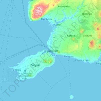
Name: Tagbilaran topographic map, elevation, terrain.
Location: Tagbilaran, Bohol, Central Visayas, 6390, Philippines (9.48026 123.69598 9.80026 124.01598)
Average elevation: 35 m
Minimum elevation: -2 m
Maximum elevation: 437 m
Make a donation
Gear up for your next adventure:
As an Amazon Associate, this site earns from qualifying purchases at no extra cost to you.
Other topographic maps
Click on a map to view its topography, its elevation and its terrain.
Chocolate Hills Natural Monument
The Chocolate Hills are conical karst hills. These hills consist of Late Pliocene to Early Pleistocene, thin to medium bedded, sandy to rubbly marine limestone. These limestones contain the abundant fossils of shallow marine foraminifera, coral, mollusks, and algae. These conical hills are geomorphological…
Average elevation: 257 m