
Make a donation
Gear up for your next adventure:
As an Amazon Associate, this site earns from qualifying purchases at no extra cost to you.
Cargèse topographic map
Click on the map to display elevation.
Make a donation
Gear up for your next adventure:
As an Amazon Associate, this site earns from qualifying purchases at no extra cost to you.
Cargèse
Son territoire est la terminaison en mer, à la punta Cargèse, d'un chaînon secondaire articulé à la pointe de Cricche (2 053 m d'altitude, sommet « à cheval » sur Ota et Albertacce) sur la chaîne principale de l'île, une ligne où s'élèvent les plus hauts sommets qui constituent une véritable barrière entre les deux départements actuels.
Make a donation
Gear up for your next adventure:
As an Amazon Associate, this site earns from qualifying purchases at no extra cost to you.
About this map
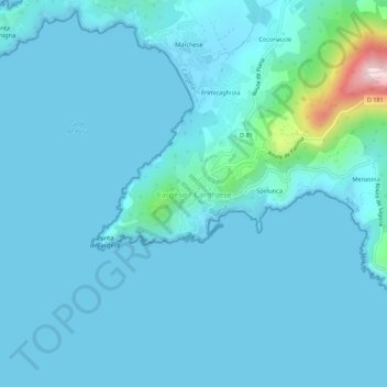
Name: Cargèse topographic map, elevation, terrain.
Average elevation: 32 m
Minimum elevation: -2 m
Maximum elevation: 394 m
Make a donation
Gear up for your next adventure:
As an Amazon Associate, this site earns from qualifying purchases at no extra cost to you.
Other topographic maps
Click on a map to view its topography, its elevation and its terrain.