
Make a donation
Gear up for your next adventure:
As an Amazon Associate, this site earns from qualifying purchases at no extra cost to you.
North Vancouver topographic map
Click on the map to display elevation.
Make a donation
Gear up for your next adventure:
As an Amazon Associate, this site earns from qualifying purchases at no extra cost to you.
About this map
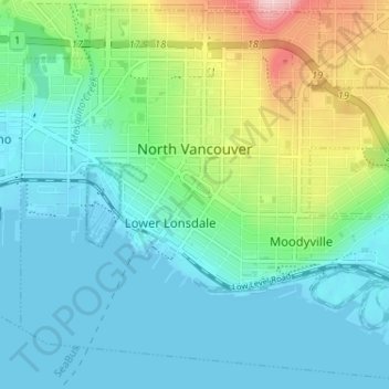
Name: North Vancouver topographic map, elevation, terrain.
Average elevation: 54 m
Minimum elevation: -2 m
Maximum elevation: 227 m
Make a donation
Gear up for your next adventure:
As an Amazon Associate, this site earns from qualifying purchases at no extra cost to you.
Other topographic maps
Click on a map to view its topography, its elevation and its terrain.
Stanley Park
Canada > British Columbia > Metro Vancouver Regional District > Vancouver
Average elevation: 14 m
White Rock
Canada > British Columbia > Metro Vancouver Regional District > White Rock > White Rock
Average elevation: 38 m
Croker Island
Canada > British Columbia > Metro Vancouver Regional District > Electoral Area A
Average elevation: 112 m