
Make a donation
Gear up for your next adventure:
As an Amazon Associate, this site earns from qualifying purchases at no extra cost to you.
Chatham topographic map
Click on the map to display elevation.
Make a donation
Gear up for your next adventure:
As an Amazon Associate, this site earns from qualifying purchases at no extra cost to you.
Chatham
The Passaic River, which rises at Millington Gorge in Long Hill Township and defines the Great Swamp, flows north along the eastern boundary of Chatham. A good crossing location, identified by Native Americans to early European settlers, figured significantly in the colonial history of the community. Fairmount Avenue ascends Long Hill perpendicularly from Main Street in the contemporary center of town to the highest elevation of the town among the Watchung Mountains. From there, one may see the lights of New York beyond the crest of the ridge hills of Summit and Short Hills. Water from artesian wells is stored at its crest to provide the drinking water for the community.
Make a donation
Gear up for your next adventure:
As an Amazon Associate, this site earns from qualifying purchases at no extra cost to you.
About this map
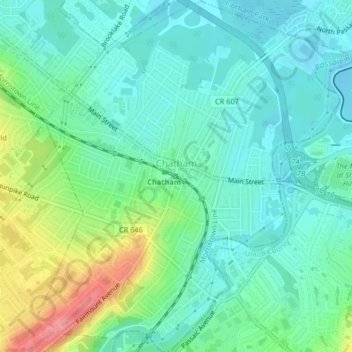
Name: Chatham topographic map, elevation, terrain.
Location: Chatham, Morris County, New Jersey, United States (40.72430 -74.39975 40.75521 -74.36307)
Average elevation: 76 m
Minimum elevation: 51 m
Maximum elevation: 141 m
Make a donation
Gear up for your next adventure:
As an Amazon Associate, this site earns from qualifying purchases at no extra cost to you.