
Make a donation
Gear up for your next adventure:
As an Amazon Associate, this site earns from qualifying purchases at no extra cost to you.
Gräfelfing topographic map
Click on the map to display elevation.
Make a donation
Gear up for your next adventure:
As an Amazon Associate, this site earns from qualifying purchases at no extra cost to you.
Gräfelfing
Aschheim | Aying | Baierbrunn | Brunnthal | Feldkirchen | Gräfelfing | Grasbrunn | Grünwald | Haar | Hohenbrunn | Höhenkirchen-Siegertsbrunn | Ismaning | Kirchheim bei München | Neubiberg | Neuried | Oberhaching | Oberschleißheim | Ottobrunn | Planegg | Pullach im Isartal | Putzbrunn | Sauerlach | Schäftlarn | Straßlach-Dingharting | Taufkirchen | Unterföhring | Unterhaching
Make a donation
Gear up for your next adventure:
As an Amazon Associate, this site earns from qualifying purchases at no extra cost to you.
About this map
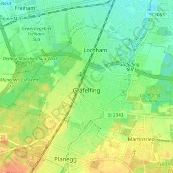
Name: Gräfelfing topographic map, elevation, terrain.
Location: Gräfelfing, Landkreis München, Bayern, 82166, Deutschland (48.10676 11.39996 48.13756 11.46567)
Average elevation: 543 m
Minimum elevation: 526 m
Maximum elevation: 564 m
Make a donation
Gear up for your next adventure:
As an Amazon Associate, this site earns from qualifying purchases at no extra cost to you.
Other topographic maps
Click on a map to view its topography, its elevation and its terrain.
Make a donation
Gear up for your next adventure:
As an Amazon Associate, this site earns from qualifying purchases at no extra cost to you.
Hailafing
Deutschland > Bayern > Landkreis München
Beigarten | Deigstetten | Ebertshausen | Epolding | Frundsbergerhöhe | Gleißentalweiher | Großdingharting | Hailafing | Holzhausen | Kirchlberg | Kleindingharting | Mühlthal | Straßlach
Average elevation: 637 m
Make a donation
Gear up for your next adventure:
As an Amazon Associate, this site earns from qualifying purchases at no extra cost to you.
Make a donation
Gear up for your next adventure:
As an Amazon Associate, this site earns from qualifying purchases at no extra cost to you.
Make a donation
Gear up for your next adventure:
As an Amazon Associate, this site earns from qualifying purchases at no extra cost to you.
Make a donation
Gear up for your next adventure:
As an Amazon Associate, this site earns from qualifying purchases at no extra cost to you.
Make a donation
Gear up for your next adventure:
As an Amazon Associate, this site earns from qualifying purchases at no extra cost to you.
Make a donation
Gear up for your next adventure:
As an Amazon Associate, this site earns from qualifying purchases at no extra cost to you.
Beigarten
Deutschland > Bayern > Landkreis München > Straßlach-Dingharting > Beigarten
Average elevation: 625 m
Make a donation
Gear up for your next adventure:
As an Amazon Associate, this site earns from qualifying purchases at no extra cost to you.
Haar
Deutschland > Bayern > Landkreis München > Haar > Haar
Das Haarer Trinkwasser wurde zunächst in Brunnen am Rande des Gemeindegebietes gefördert. Um die Versorgung des wachsenden Ortes auch für die Zukunft langfristig zu sichern, wurden neue Quellen erschlossen. So stammt seit 2011 das geförderte Wasser aus einem Gebiet im Höhenkirchener Forst, in dem das…
Average elevation: 543 m
Make a donation
Gear up for your next adventure:
As an Amazon Associate, this site earns from qualifying purchases at no extra cost to you.
Make a donation
Gear up for your next adventure:
As an Amazon Associate, this site earns from qualifying purchases at no extra cost to you.