Geolocate

Insh topographic map

Click on the map to display elevation.

About this map

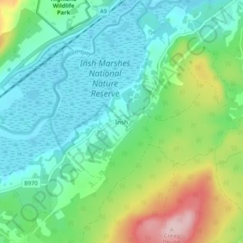
Name: Insh topographic map, elevation, terrain.

Location: Insh, Highland, Scotland, PH21 1NT, United Kingdom (57.07071 -3.97826 57.11071 -3.93826)

Average elevation: 275 m

Minimum elevation: 215 m

Maximum elevation: 439 m

Other topographic maps

Click on a map to view its topography, its elevation and its terrain.

Loch Ness

United Kingdom > Scotland > Highland > Dores

Average elevation: 340 m

Glen Coe

United Kingdom > Scotland > Highland > Glencoe

Average elevation: 414 m

Strathnairn

United Kingdom > Scotland > Highland > Daviot

Average elevation: 268 m

Gear up for your next adventure:

🌬️Windbreaker Jackets - Wind protection jackets
🔥Camping Stoves - Portable stoves for outdoor cooking
🕯️Emergency Whistles - Safety whistles for hiking
Outdoor Coffee Makers - Enjoy quality coffee at the summit of your favorite peak
🎽Base Layers - Thermal base layers

As an Amazon Associate, this site earns from qualifying purchases at no extra cost to you.