
Make a donation
Gear up for your next adventure:
As an Amazon Associate, this site earns from qualifying purchases at no extra cost to you.
Culiacán topographic map
Click on the map to display elevation.
Make a donation
Gear up for your next adventure:
As an Amazon Associate, this site earns from qualifying purchases at no extra cost to you.
Culiacán
Culiacán is located in the central region of the State of Sinaloa, forming part of the Northwest of Mexico. The coordinates that correspond to it are 24 ° 48'15 "N (latitude) by 107 ° 25'52" W (West), with an altitude of 54 meters above sea level.
Make a donation
Gear up for your next adventure:
As an Amazon Associate, this site earns from qualifying purchases at no extra cost to you.
About this map
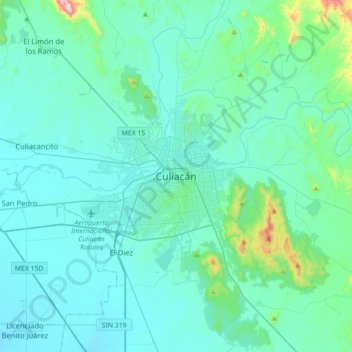
Name: Culiacán topographic map, elevation, terrain.
Average elevation: 85 m
Minimum elevation: 6 m
Maximum elevation: 764 m
Make a donation
Gear up for your next adventure:
As an Amazon Associate, this site earns from qualifying purchases at no extra cost to you.
Other topographic maps
Click on a map to view its topography, its elevation and its terrain.
Make a donation
Gear up for your next adventure:
As an Amazon Associate, this site earns from qualifying purchases at no extra cost to you.