
Alto Gállego topographic map
Interactive map
Click on the map to display elevation.
About this map
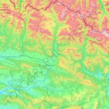
Name: Alto Gállego topographic map, elevation, terrain.
Location: Alto Gállego, Huesca, Aragon, Spain (42.29555 -0.68041 42.84941 -0.06586)
Average elevation: 1,396 m
Minimum elevation: 542 m
Maximum elevation: 3,311 m
Other topographic maps
Click on a map to view its topography, its elevation and its terrain.
Vitales
Spain > Aragon > Hoya de Huesca / Plana de Uesca > Monflorite-Lascasas
Average elevation: 492 m
Sistema Ibérico
Spain > Aragon > Tarazona y el Moncayo > Tarazona
The geology of the Iberian System is complex, for it can hardly be defined as a homogeneous system. It is composed of a haphazard and motley series of mountain ranges, massifs, plateaus and depressions without a definite common petrologic composition and overall structure. Nummulite limestone, marble and…
Average elevation: 1,906 m
Riglos
Spain > Aragon > Hoya de Huesca / Plana de Uesca > Las Peñas de Riglos
Average elevation: 726 m
Pla de Beronia
Spain > Aragon > Bajo Aragón-Caspe / Baix Aragó-Casp > Fabara / Favara
Average elevation: 215 m
Huesca
Huesca lies on a plateau in the northern region of Aragón, with an elevation of 488 m (1,601.05 ft) above sea level. Close to the city lie the Sierra de Guara mountains, which reach 2,077 m. The geographical coordinates of the city are: 42° 08´ N, 0° 24´ W.
Average elevation: 589 m