Geolocate

Buckland topographic map

Click on the map to display elevation.

About this map

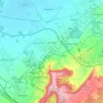
Name: Buckland topographic map, elevation, terrain.

Location: Buckland, Buckinghamshire, England, United Kingdom (51.76276 -0.74103 51.83094 -0.67750)

Average elevation: 131 m

Minimum elevation: 80 m

Maximum elevation: 270 m

Gear up for your next adventure:

🪢550 Survival Paracord - Versatile cordage for gear repair and emergency lashing
Lightweight Tents - Compact tents for backpacking
☀️Portable Solar Chargers - High-efficiency panels to hang on your backpack while walking
🔥Windproof Plasma Lighters - USB rechargeable lighters that work in high-altitude winds
🗺️Topographic Maps - Detailed maps for hiking and navigation

As an Amazon Associate, this site earns from qualifying purchases at no extra cost to you.