
Mount Morgan topographic map
Interactive map
Click on the map to display elevation.
About this map
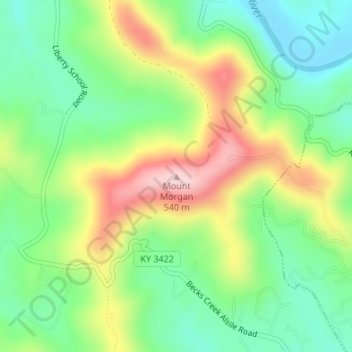
Name: Mount Morgan topographic map, elevation, terrain.
Location: Mount Morgan, Whitley County, Kentucky, 40769, USA (36.74392 -84.19471 36.74402 -84.19461)
Average elevation: 374 m
Minimum elevation: 274 m
Maximum elevation: 530 m
Other topographic maps
Click on a map to view its topography, its elevation and its terrain.
Middlesborough
USA > Kentucky > Middlesborough
Middlesborough, Bell County, Kentucky, USA
Average elevation: 406 m
Madisonville
USA > Kentucky > Madisonville
Madisonville, Hopkins County, Kentucky, 42431, USA
Average elevation: 136 m
Mammoth Cave
USA > Kentucky > Mammoth Cave
Mammoth Cave, Edmonson County, Kentucky, USA
Average elevation: 214 m
Cumberland River
Cumberland River, Monroe County, Kentucky, 42711, USA
Average elevation: 301 m