
Make a donation
Gear up for your next adventure:
As an Amazon Associate, this site earns from qualifying purchases at no extra cost to you.
San Antonio topographic map
Click on the map to display elevation.
Make a donation
Gear up for your next adventure:
As an Amazon Associate, this site earns from qualifying purchases at no extra cost to you.
San Antonio
San Antonio is approximately 75 miles (121 km) to the southwest of its neighboring city, Austin, the state capital, about 190 miles (310 km) west of Houston, and about 250 miles (400 km) south of the Dallas–Fort Worth area. The city has a total area of 465.4 square miles (1,205.4 km2); 460.93 square miles (1,193.8 km2) of San Antonio's total area is land and 4.5 square miles (11.7 km2) of it is water. The city's gently rolling terrain is dotted with oak trees, forested land, mesquite, and cacti. The Texas Hill Country reaches into the far northern portions of the city. San Antonio sits on the Balcones Escarpment. Its altitude is approximately 662 feet (202 m) above sea level.
Make a donation
Gear up for your next adventure:
As an Amazon Associate, this site earns from qualifying purchases at no extra cost to you.
About this map
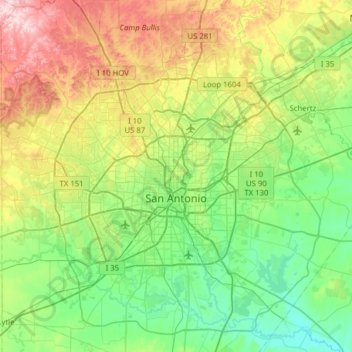
Name: San Antonio topographic map, elevation, terrain.
Location: San Antonio, Bexar County, Texas, United States (29.18626 -98.81319 29.73096 -98.22300)
Average elevation: 247 m
Minimum elevation: 117 m
Maximum elevation: 575 m
Make a donation
Gear up for your next adventure:
As an Amazon Associate, this site earns from qualifying purchases at no extra cost to you.
Other topographic maps
Click on a map to view its topography, its elevation and its terrain.
Make a donation
Gear up for your next adventure:
As an Amazon Associate, this site earns from qualifying purchases at no extra cost to you.
Make a donation
Gear up for your next adventure:
As an Amazon Associate, this site earns from qualifying purchases at no extra cost to you.