
Potosí topographic map
Interactive map
Click on the map to display elevation.
About this map
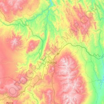
Name: Potosí topographic map, elevation, terrain.
Location: Potosí, Provincia Tomás Frías, Potosí, Bolivia (-19.80525 -65.96351 -19.26264 -65.54740)
Average elevation: 3,961 m
Minimum elevation: 3,104 m
Maximum elevation: 5,014 m
Other topographic maps
Click on a map to view its topography, its elevation and its terrain.
Plaza Central de Chira Coro
Bolivia > Potosí > Provincia Tomás Frías > Municipio Yocalla > Chira Coro
Plaza Central de Chira Coro, Chira Coro, Municipio Yocalla, Provincia Tomás Frías, Potosí, Bolivia
Average elevation: 3,728 m