Geolocate

Bacong topographic map

Click on the map to display elevation.

About this map

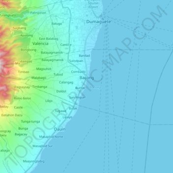
Name: Bacong topographic map, elevation, terrain.

Location: Bacong, Negros Oriental, Central Visayas, 6216, Philippines (9.19450 123.20083 9.27613 123.38924)

Average elevation: 94 m

Minimum elevation: 0 m

Maximum elevation: 1,095 m

Other topographic maps

Click on a map to view its topography, its elevation and its terrain.

Vallehermoso

Philippines > Negros Oriental

Average elevation: 69 m

Gear up for your next adventure:

🧼Biodegradable Outdoor Soap - Clean gear and yourself without harming the local ecosystem
🌧️Rain Jackets - Waterproof jackets for hiking
📖Australian Bush Survival Books - Local knowledge on finding water and surviving the outback
🧦Merino Wool Hiking Socks - Moisture-wicking socks to prevent blisters during long topographic surveys
🌬️Windbreaker Jackets - Wind protection jackets

As an Amazon Associate, this site earns from qualifying purchases at no extra cost to you.