Geolocate

Uckfield topographic map

Click on the map to display elevation.

About this map

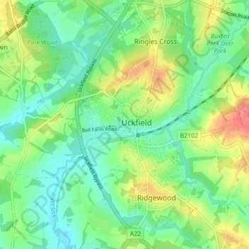
Name: Uckfield topographic map, elevation, terrain.

Location: Uckfield, Wealden District, East Sussex, England, United Kingdom (50.94883 0.07950 50.99231 0.12405)

Average elevation: 36 m

Minimum elevation: 11 m

Maximum elevation: 82 m

Gear up for your next adventure:

💡Collapsible Camping Lanterns - Illuminate your base camp or tent for map studying at night
🎒Daypacks - Compact backpacks for short hikes
💧Personal Water Filters - Drink safely from streams and lakes identified on your map
🎒Ultralight Backpacks - Lightweight packs for long hikes
🔪Camping Knives - Multi-purpose outdoor knives

As an Amazon Associate, this site earns from qualifying purchases at no extra cost to you.