
Richland topographic map
Interactive map
Click on the map to display elevation.
About this map
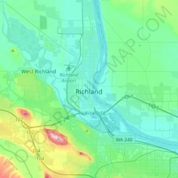
Name: Richland topographic map, elevation, terrain.
Location: Richland, Benton County, Washington, United States (46.19440 -119.40044 46.37063 -119.21148)
Average elevation: 160 m
Minimum elevation: 93 m
Maximum elevation: 483 m
According to the United States Census Bureau, the city has a total area of 39.11 square miles (101.29 km2), of which, 35.72 square miles (92.51 km2) is land and 3.39 square miles (8.78 km2) is water. Elevation at the airport is 120 m (390 ft).