
Pleasanton topographic map
Interactive map
Click on the map to display elevation.
About this map
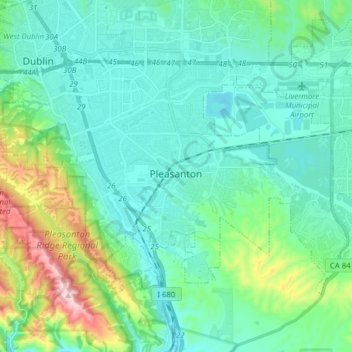
Name: Pleasanton topographic map, elevation, terrain.
Location: Pleasanton, Alameda County, California, United States (37.62006 -121.95497 37.70304 -121.79892)
Average elevation: 187 m
Minimum elevation: 70 m
Maximum elevation: 663 m
Other topographic maps
Click on a map to view its topography, its elevation and its terrain.
Livermore
United States > California > Alameda County
Livermore, Alameda County, CAL Fire Northern Region, California, 94550, United States
Average elevation: 184 m
Emeryville
United States > California > Alameda County > Emeryville
Emeryville, Alameda County, California, 94608, United States
Average elevation: 13 m