
Thank you for supporting this site ❤️
Make a donation
Make a donation
Gear up for your next adventure:
As an Amazon Associate, this site earns from qualifying purchases at no extra cost to you.
Birkenau topographic map
Click on the map to display elevation.
Thank you for supporting this site ❤️
Make a donation
Make a donation
Gear up for your next adventure:
As an Amazon Associate, this site earns from qualifying purchases at no extra cost to you.
About this map
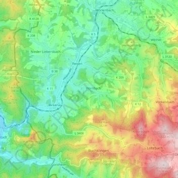
Name: Birkenau topographic map, elevation, terrain.
Location: Birkenau, Kreis Bergstraße, Hesse, 69488, Germany (49.53505 8.68031 49.60197 8.77624)
Average elevation: 261 m
Minimum elevation: 112 m
Maximum elevation: 531 m
Thank you for supporting this site ❤️
Make a donation
Make a donation
Gear up for your next adventure:
As an Amazon Associate, this site earns from qualifying purchases at no extra cost to you.