Geolocate

Staffa topographic map

Click on the map to display elevation.

👉 Easily get elevation data in JSON, GeoTIFF and KML formats using Elevation API
Thank you for supporting this site ❤️
Make a donation

About this map

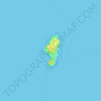
Name: Staffa topographic map, elevation, terrain.

Location: Staffa, Argyll and Bute, Scotland, United Kingdom (56.43095 -6.34685 56.44050 -6.33676)

Average elevation: 0 m

Minimum elevation: -1 m

Maximum elevation: 30 m

Other topographic maps

Click on a map to view its topography, its elevation and its terrain.

Garelochhead

United Kingdom > Scotland > Argyll and Bute

Average elevation: 110 m

Gear up for your next adventure:

🎽Base Layers - Thermal base layers
🆘Personal Locator Beacons (PLB) - Satellite emergency beacons for life-saving help in areas with no mobile coverage
🗺️Topographic Maps - Detailed maps for hiking and navigation
Survival Blankets - Emergency thermal blankets
🦯Adjustable Trekking Poles - Reduce impact on knees when descending steep topographic ridges

As an Amazon Associate, this site earns from qualifying purchases at no extra cost to you.