
Te Anau topographic map
Click on the map to display elevation.
About this map
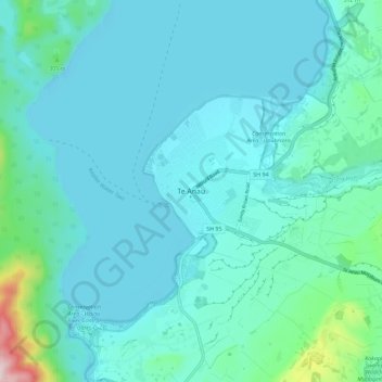
Name: Te Anau topographic map, elevation, terrain.
Average elevation: 249 m
Minimum elevation: 197 m
Maximum elevation: 614 m
Other topographic maps
Click on a map to view its topography, its elevation and its terrain.
Doubtful Sound
New Zealand > Southland > Southland District > Fiordland Community
Average elevation: 560 m
Milford Sound
New Zealand > Southland > Southland District > Fiordland Community
Average elevation: 655 m
Darran Mountains
New Zealand > Southland > Southland District > Fiordland Community
Average elevation: 911 m
Skippers Range
New Zealand > Southland > Southland District > Fiordland Community
Average elevation: 595 m
Wick Mountains
New Zealand > Southland > Southland District > Fiordland Community
Average elevation: 1,185 m
Mararoa River
New Zealand > Southland > Southland District > Fiordland Community
Average elevation: 681 m
Lake Quill
New Zealand > Southland > Southland District > Fiordland Community
Average elevation: 1,228 m
Lake Te Au
New Zealand > Southland > Southland District > Fiordland Community
Average elevation: 597 m
Donne Glacier
New Zealand > Southland > Southland District > Fiordland Community
Average elevation: 1,826 m
Age Glacier
New Zealand > Southland > Southland District > Fiordland Community
Average elevation: 1,753 m
Wild Natives River
New Zealand > Southland > Southland District > Fiordland Community
Average elevation: 769 m
Cleddau River
New Zealand > Southland > Southland District > Fiordland Community
Average elevation: 800 m
Pembroke Glacier
New Zealand > Southland > Southland District > Fiordland Community
Average elevation: 1,211 m
Pitt River
New Zealand > Southland > Southland District > Fiordland Community
Average elevation: 706 m