
Make a donation
Gear up for your next adventure:
As an Amazon Associate, this site earns from qualifying purchases at no extra cost to you.
Nakrekal topographic map
Click on the map to display elevation.
Make a donation
Gear up for your next adventure:
As an Amazon Associate, this site earns from qualifying purchases at no extra cost to you.
Nakrekal
Nakrekal is located at 17°09′53″N 79°25′39″E / 17.16469834°N 79.42747827°E / 17.16469834; 79.42747827. It has an average elevation of 240 metres (790 ft).
Make a donation
Gear up for your next adventure:
As an Amazon Associate, this site earns from qualifying purchases at no extra cost to you.
About this map
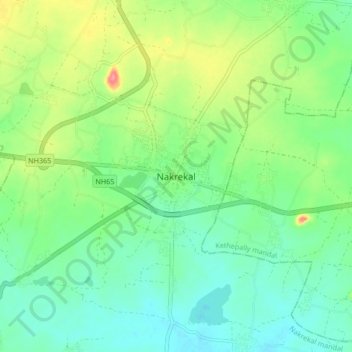
Name: Nakrekal topographic map, elevation, terrain.
Location: Nakrekal, Nakrekal mandal, Nalgonda, Telangana, 508211, India (17.12476 79.38740 17.20476 79.46740)
Average elevation: 207 m
Minimum elevation: 182 m
Maximum elevation: 260 m
Make a donation
Gear up for your next adventure:
As an Amazon Associate, this site earns from qualifying purchases at no extra cost to you.