Geolocate

Novi topographic map

Click on the map to display elevation.

About this map

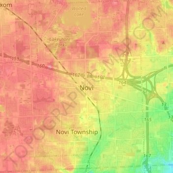
Name: Novi topographic map, elevation, terrain.

Location: Novi, Oakland County, Michigan, United States (42.43518 -83.55521 42.52711 -83.43367)

Average elevation: 280 m

Minimum elevation: 230 m

Maximum elevation: 309 m

Other topographic maps

Click on a map to view its topography, its elevation and its terrain.

Lake Bars Leak

United States > Michigan > Oakland County

Average elevation: 291 m

Gear up for your next adventure:

📱Tablet Tripod Mounts - Steady platforms for viewing digital maps or taking long exposures
📚Map Reading & Navigation Guides - Master the art of interpreting topographic contours and symbols
👕UPF 50+ Sun Shirts - Essential protection against the harsh Australian sun during field work
🎽Hiking Clothing - Breathable clothing for hiking
🧢Wide Brim Sun Hats - Maximum coverage for the face and neck while out in the open

As an Amazon Associate, this site earns from qualifying purchases at no extra cost to you.