
Make a donation
Gear up for your next adventure:
As an Amazon Associate, this site earns from qualifying purchases at no extra cost to you.
Lake Winnipeg topographic map
Click on the map to display elevation.
Make a donation
Gear up for your next adventure:
As an Amazon Associate, this site earns from qualifying purchases at no extra cost to you.
About this map
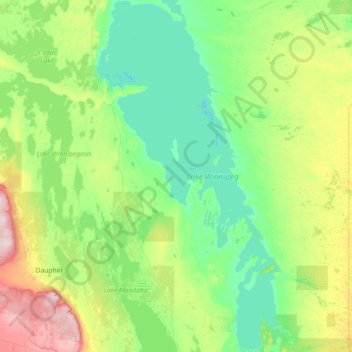
Name: Lake Winnipeg topographic map, elevation, terrain.
Location: Lake Winnipeg, Manitoba, Canada (50.35847 -99.26855 53.87945 -96.26042)
Average elevation: 275 m
Minimum elevation: 212 m
Maximum elevation: 810 m
Make a donation
Gear up for your next adventure:
As an Amazon Associate, this site earns from qualifying purchases at no extra cost to you.
Other topographic maps
Click on a map to view its topography, its elevation and its terrain.
Goulbourne
Canada > Manitoba > Division No. 18 > Municipality of West Interlake
Average elevation: 251 m
Make a donation
Gear up for your next adventure:
As an Amazon Associate, this site earns from qualifying purchases at no extra cost to you.