Geolocate
👉 Easily get elevation data in JSON, GeoTIFF and KML formats using Elevation API
Thank you for supporting this site ❤️
Make a donation

Selsey topographic map

Click on the map to display elevation.

👉 Easily get elevation data in JSON, GeoTIFF and KML formats using Elevation API
Thank you for supporting this site ❤️
Make a donation

About this map

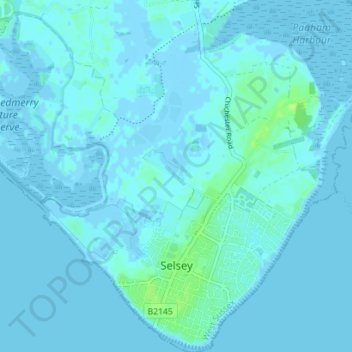
Name: Selsey topographic map, elevation, terrain.

Location: Selsey, Chichester, West Sussex, England, United Kingdom (50.72178 -0.81895 50.76629 -0.74938)

Average elevation: 1 m

Minimum elevation: -4 m

Maximum elevation: 9 m

Gear up for your next adventure:

🧥Insulated Down Jackets - High warmth-to-weight ratio for cold nights in the high country
🕶️Polarized Sunglasses - UV protection sunglasses for outdoors
🌧️Rain Jackets - Waterproof jackets for hiking
☀️Portable Solar Chargers - High-efficiency panels to hang on your backpack while walking
🌿Flora and Fauna Field Guides - Identify the plants and animals you encounter on your route

As an Amazon Associate, this site earns from qualifying purchases at no extra cost to you.