
Garessio topographic map
Interactive map
Click on the map to display elevation.
About this map
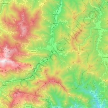
Name: Garessio topographic map, elevation, terrain.
Location: Garessio, Cuneo, Piedmont, 12075, Italy (44.14164 7.86262 44.25424 8.09728)
Average elevation: 961 m
Minimum elevation: 129 m
Maximum elevation: 2,112 m
Other topographic maps
Click on a map to view its topography, its elevation and its terrain.
Strepeis
Italy > Piedmont > Cuneo > Bagni di Vinadio
Strepeis, Bagni di Vinadio, Vinadio, Cuneo, Piedmont, Italy
Average elevation: 1,758 m
San Bernolfo
Italy > Piedmont > Cuneo > Vinadio
San Bernolfo, Vinadio, Cuneo, Piedmont, Italy
Average elevation: 2,036 m
San Rocco Castagnaretta
Italy > Piedmont > Cuneo > Cuneo > San Rocco Castagnaretta
San Rocco Castagnaretta, Cuneo, Piedmont, 12100, Italy
Average elevation: 569 m
Limone Piemonte
Limone Piemonte, Cuneo, Piedmont, 12015, Italy
Average elevation: 1,619 m