
Municipal Unit of Asklipieio topographic map
Interactive map
Click on the map to display elevation.
About this map
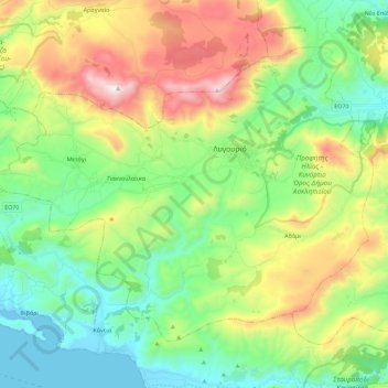
Name: Municipal Unit of Asklipieio topographic map, elevation, terrain.
Average elevation: 399 m
Minimum elevation: -2 m
Maximum elevation: 1,188 m
Other topographic maps
Click on a map to view its topography, its elevation and its terrain.
Πρ. Ηλίας,Κάμπος,Αυλώνα,Μικρό&Μεγάλο Ασπροβούνι,Λουτρό,Θωμά,Παπούλια,Μαυροβούνι,Αγ. Ιωάννης,Καταφύκι,Κασιδιάρη&Κάμπος Δ. Κρανιδίου
Greece > Peloponnese, Western Greece and the Ionian > Argolis Regional Unit > Municipal Unit of Kranidi
Πρ. Ηλίας,Κάμπος,Αυλώνα,Μικρό&Μεγάλο Ασπροβούνι,Λουτρό,Θωμά,Παπούλια,Μαυροβούνι,Αγ. Ιωάννης,Καταφύκι,Κασιδιάρη&Κάμπος Δ. Κρανιδίου, Municipal Unit of Kranidi, Municipality of Ermionida, Argolis Regional Unit, Peloponnese Region, Peloponnese, Western Greece and the Ionian, Greece
Average elevation: 121 m