
Limestone County topographic map
Interactive map
Click on the map to display elevation.
About this map
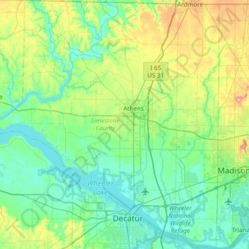
Name: Limestone County topographic map, elevation, terrain.
Location: Limestone County, Alabama, USA (34.55069 -87.28091 34.99901 -86.78340)
Average elevation: 209 m
Minimum elevation: 165 m
Maximum elevation: 377 m
Other topographic maps
Click on a map to view its topography, its elevation and its terrain.
East Chapman
USA > Alabama > East Chapman
East Chapman, Butler County, Alabama, 36033, USA
Average elevation: 93 m
Clear Creek Campground
USA > Alabama > Falls City
Clear Creek Campground, County Road 8, Falls City, Winston County, Alabama, USA
Average elevation: 180 m
Tennessee River
Tennessee River, Madison County, Alabama, 35754:35803, USA
Average elevation: 244 m