
Rheingau-Taunus-Kreis topographic map
Interactive map
Click on the map to display elevation.
About this map
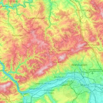
Name: Rheingau-Taunus-Kreis topographic map, elevation, terrain.
Location: Rheingau-Taunus-Kreis, Hesse, Germany (49.97180 7.77241 50.29609 8.41149)
Average elevation: 288 m
Minimum elevation: 72 m
Maximum elevation: 621 m
Other topographic maps
Click on a map to view its topography, its elevation and its terrain.
Wambach
Germany > Hesse > Rheingau-Taunus-Kreis > Schlangenbad
Wambach, Schlangenbad, Rheingau-Taunus-Kreis, Hesse, Germany
Average elevation: 425 m